hikes-and-walks near Casta Diva Spa
The Kilometer of Knowledge (Chilometro della Conoscenza) is a path on the western shore of Lake Como - a kilometer long - that starts from Villa Olmo, crosses a bridge through the municipality of Serre, Villa del Grumello, and ends at Villa Sucota....

Located above the village of Cernobbio, it is the starting point of the famous route known as “Via dei Monti Lariani", a hiking and cycling trail of 125 km on the mountains of the western shore of Lake Como. Many of the villages connected by the...
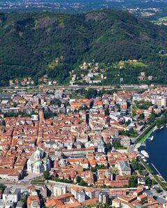
Inside Como’s walled city are many pedestrian friendly squares. Explore Piazza Fedele’s cafes or restaurants in an ambiance that is a bit more quiet than the Piazza Duomo....

Montepiatto is a small settlement of houses scattered in the mountains above Torno. After a windy path a several steep staircases, you'll be awarded with beautiful views of the Como lake basin....
The whole territory of the Larian Triangle and, in particular, its westernmost end, is characterized by the abundant presence of so-called "erratics" or "boulders" left behind by glaciers. Those found in Torno and Blevio have been declared national...
Fellaria Glacier is located in Valmalenco (SO), upstream of Lake Gera and Bignami Refuge. To reach the lake, from the refuge, you continue following the Marson Glaciological Trail towards the eastern tongue of the glacier.The lake is located in a...
15 minutes to Lake Como going up from Menaggio, the Grotte di Rescia are a series of caves unified to a single complex at the beginning of the 20th century, wind along a tourist route of about 500 mt on the mountain slopes, on the eastern shore of...
“Path of Expression”, which was inaugurated in 2014, goes through the Regional Forest Valle Intel and it is an interesting trail to visit where visitors can encounter along this magical trail between art and nature, many wooden sculptures and carved...
Lago Darengo is a beautiful mountain lake situated at 1790 m. altitude. The ideal starting point is from Crotto Dangri (650 m) above Gravedona ed Uniti, 10 km away from Lake Como and 3 km after Livo village (be carefull on the last 3 km which are...
A hike that starts not far from Como with spectacular views of Lake Como and the Italian and Swiss Alps, Monte Colmegnone (m 1.383) is also known as Poncione di Laglio. The altitude gain of the hike is about 1000 meters. You can reach it from either...
The Gazzirola (also known as Garzirola) 2112 metres, is a mountain of the Lugano Prealps on the Swiss-Italian border. It is a moderately difficult hike in Val Cavargna near Lake Como. This hike rewards you with sweeping panorama over Lake Como (you...
Located on the northern slope of Monti Valletto (m. 2370) and Ponteranica (m. 2378). The construction of the dam, which occurred in the early years after World War II, expanded the lake’s capacity. Part of a popular hike to enjoy the beautiful views...
This waterfall originates from a cave at the bottom of the Palio Costa, near Morterone in Val Taleggio. There is also a popular pool deep enough for those who wish to brave a jump. The Enna can be visited along a spectacular gorge about 3 km long,...
The ice cave of Moncodeno is the most famous cave with glacial deposits in the Lombardia Region (even described by Leonardo Da Vinci). It is the symbol of the whole plateau of Moncodeno with its 1,190 m depth, it is one of the deepest caves in Italy...
Located a few kilometers from Bellagio in the Larian Triangle. Highest of all mountains on the promontory, it offers unparalleled views of the lake and breathtaking panoramas. Along the way you will encounter large boulders (Pitera Lentina) left...
Spectacular views of Lake Como reward your hike to Pilone and Sasso San Martino, the mountain that is directly above the town of Griante. This is an easy to moderate hike. It takes about 1.5 to 2.5 hours to walk to Pilone, and another 45 minutes to...
This cave is located above Tremezzo lasting a little less than half a day and is one of the easiest ones to undertake. The entrance of the cave is reached after 50 minutes of walking while the entire cave (400 meters) takes about 2 hours to...
Jurassic cave located just north of Erba. The entrance is enormous frequently compared to Milan’s Cathedral at about 45 meters in height, 38 wide and over 400 in length. Use of the cave dates back to Paleolithic times as evidenced by flints and...
The white church of San Calimero with its characteristic sloping roof red, is very well known in Northern Grigna. It stands clearly visible looking at the mountains above Pasturo and offers a spectacular view, overlooking the Valsassina, Zuccone...
The valley opens up to display a wide, green landscape that is pristine and wild. You can reach the Sanctuary of Madonna della Neve, symbol of the valley, and a rifugio of the same name where the view opens to the mountain Pizzo dei Tre Signori. It...
The walk of lovers is a short pedestrian path cantilevered over water in Varenna. It affords romantic views of Lake Como, the mountains, and the small village with its colourful houses perched at the foot of the cliff which is crowned at the top by...
One of the most interesting areas in Lombardy from a geological, geomorphological, and paleonthological point of view. Highlights include: Limestone pavement (karstic phenomenon); stratified rocks and caves; "Acqua del Fò", a monumental a...
The Prim’Alpe Visitor’s Centre is the starting point for this interesting trail near Canzo. The hike is easy, even for young aged children. During your trek you will meet elves, gnomes, the drunken donkey and other many interesting figures, together...
An extraordinary natural sight the Troggia waterfall in Introbio Valsassina mentioned by Leonardo da Vinci in his Codex Atlanticus. The Troggia creek comes from Lake Sasso at the foot of Pizzo of Tre Signori and goes on along the Biandino valley...
Sighignola is a mountain of the Como Prealps, located on the border between the Italian region of Lombardy and the Swiss canton of Ticino. A panoramic terrace just below the summit, and directly on the Italian side of the border, provides a...
Crocione in Italian means large cross, and that is what adorns the top of Monte Crocione, a 1641 metre peak directly above the town of Griante. From here you will experience breathtaking views of Lake Como, and the Swiss and Italian Alps....
A gentle hike to the small chapel of San Domenico (800m) which rewards you with a spectacular view of Lake Como and the surrounding mountains....
A prominent natural arch located in Formazione di Esino is a unique opening on the side of a mountain. It is a relic of a previous large karst system in the area that is evidenced by several cavities. The present morphology is due to collapse or...
Monti di Nava (850m), also referred to simply as Nava, is an area of alpine pastures in the mountains above Griante and at the foot of Monte Crocione. It was traditionally used for grazing animals such as cows and goats during the summer months, and...
Monte Palanzone is a mountain 1436 meters high--only second to Monte San Primo in the area. It can be reached in several ways but the most populare is from Como via the funicular to Brunate, location of the lighthouse and centuries old church,...
Hike that follows the course of a river, including potholes, waterfalls and waterholes of rare beauty. Forcing the hiker to numerous fords that, like it or not, they will often cool off your feet, especially during periods when the water flow is...
The San Tomaso Park occupies the lower foothills of the ridge of Corno Birone (1,116 m), Mount Rai (1,250 m), Mount Prà Santo (1,245 m) and the Colma di Val Ravella (939 m). The park offers a beautiful landscape from just a short distance from the...
Il Rogolone is one of the biggest oak trees in Europe. It stands in a clearing in the woods near Velzo. The tree is almost 300 years old is 25 m high and its trunk has a circumference of 790 cm. Il Rogolone can be reached over an easy path either...
The waterfall Cenghen (or Waterfall Valley Monastery) is located at an altitude of about 600 meters above sea level. This waterfall is crossed by the waters of the stream Zerbo and, with a height of about 50 meters. The waterfall is easily reached...
The Bear's Cave or Bear's Hole, is found on the northern extreme of Laglio, in the Torriggia area, at about 400 meters above Lake Como. You arrive by climbing from Torriggia via a mountain path. The grotto is famous for the petrified bones found...
Although it is not the highest mountain in the Lake Como area, the Grigna (pronounced "greenya") is by far the most prominent. For those of you that will be visiting the western shore of Lake Como, especially in the mid lake region, this is the...
One of the most walked and photographed passageways in the heart of Bellagio that is home to fashionable boutiques, restaurants and a variety of shops. This is just one of the many narrow streets that can be explored affording riveting views of the...
Monte Legnone is the highest peak in the immediate Lake Como area. The view from the top is definitely unforgettable. Monte Legnone is 2,610 metres high making it the highest peak in the Lake Como area. It is located at the north end of the lake,...
A spectacular balcony over Lake Como, this hike will reward you with some of the most breath taking views of the lake. Monte Bregagno can be reached by first going to the town of Breglia by car or by bus. From there you can hike to Rifugio Menaggio,...
The Gorge, created by the river Pioverna, is a natural canyon where giant bowls and incredible caves have been carved out by the water over the centuries. A concrete footbridge allows visitors to admire this beauty from an extremely unique location....
The Greenway" is a leisurely and pleasant walk between Colonno and Cadenabbia following traces of the Antica Strada Regina, the antique connection road was built by the Romans. This 10 km long itinerary leads through ancient villages with wonderful...
The “Sentiero del Viandante" is an interesting route dating back to the Roman period, which runs along the eastern coast of Lake Como, from Abbadia Lariana to Piantedo, for 45 km. Fitted out in 1989, this walking path offers those who walk along it...
Situated above the town of Menaggio; from Rifugio Menaggio you can reach the top of Monte Grona (1736 m) from where one can admire one of the best views of the Pre-Alps; if the day is clear enough, many peaks of the Alps from Monviso to Bernina....